
GENEVA LAKE
Data and Information
EDUCATIONAL BROCHURES ABOUT GLEA
Click on the pictures below.
Then click on "Go to Link" at the very bottom of that next page to open a PDF.


Lake Info

Zebra Mussel Survey
During the summer of 2020, three zebra mussels substrates were deployed in Geneva Lake to monitor their colonization by zebra mussels. Sites were located on the east end of the lake, Rivera pier, west end of the lake, Gordy's pier, and on the south eastern shore, Hillside Rd pier. Deployment this year was different than in past deployments as the substrates were counted only once at the end of summer. The substrates were in the water for 115 days. In the past, substrates were removed, counted and cleaned each month during the summer resulting in the maximum deployment without cleaning being 63 days.
2020 mussel colonization rates ranged from 25 mussels per day per substrate to 37 mussels per substrate. These rates are higher than those listed for 2016. That may be the results of the substrates not being cleaned during the 2020 deployment. During the 2016 the substrates were cleaned at the end in July and August.
The west end of the lake showed the highest colonization rate and ultimately the highest density during 2020 and during the later two periods of 2016 deployment. Although there were a few mussels observed on the substrates that looked like Quagga mussels, there has not been a confirmed identification of them in Geneva Lake as of 2020.

Zebra Muscle Substrate
Trophic State Index
A trophic state index (TSI) assigns a numerical value to specific measurement found in the lake that are representative of the lake’s overall condition. There are several trophic status indexes that are used but for the purpose of understanding Geneva Lake’s trophic condition, the Wisconsin Trophic State Index is used. Generally, the higher the trophic value the worse the water quality.
Trophic state refers to the amount of biological activity in a lake. The more trophic a lake is the more fertile it is. A very biologically active, fertile lake with a lot of plants, would be considered a eutrophic lake while a lake with very little plant life and not much fertility would be considered an oligotrophic lake. Lakes that fall in between are referred to a mesotrophic lakes. Three measurements are used to evaluate a lake’s fertility, total phosphorus, chlorophyll a, and secchi disks or water clarity. Phosphorus is a vital nutrient that is often the limiting nutrient for plant growth in lakes, meaning the more phosphorus in a lake, the more plant growth. Chlorophyll a is a color pigment found in green plants. A measure of chlorophyll a in the water column is an indirect measurement of plant density in the open water which is mostly comprised of plankton. Secchi disk readings measure the depth of light penetration into the water. All three are related; as phosphorus increases, so does chlorophyll a which allows for more algae in the water and therefore, less light penetrates into the water.
The figure below shows the plotted TSI values for Geneva Lake’s total phosphorus (TP), chlorophyll (chl ”a”), and secchi disks over the last 18 years. Geneva Lake’s secchi disk TSI value is mostly in the oligotrophic range, the Chl ”a” TSI value moves between mesotrophic and oligotrophic, and lastly, only the total phosphorus TSI value ever reaches eutrophic on a few occasions. Based upon this information, Geneva lake would be classified as a relatively clean lake that is in transition between oligotrophic and mesotrophic states.


Chlorophyll a
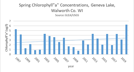

Chlorophyll "a" is the color pigment found in plants that gives it its green color and allows the plant to photosynthesize. Its measurement helps us to estimate the amount of free floating plants (phytoplankton) in the lake. High chlorophyll levels are beneficial for productivity and creating oxygen, but too much can result in algae blooms that can be harmful for organisms.


A secchi disk is a round disk, 20 cm. in diameter, that is colored alternately in black and white quadrants to measure water clarity. The disk is lowered in the water and the depth at which it can no longer be seen is recorded. It is then slowly brought back up and the depth at which it reappears is recorded. The two depths are then averaged for a Secchi depth recording.

Temperature and Oxygen Stratification
As is typical with most deeper lakes in the northern hemisphere, Geneva Lake stratifies during the summer and winter and mixes during the spring and and fall. When the ice melts in the spring, the lake mixes throughout the water column until the surface waters are warmed by the warmer days. The lake stays stratified with the warmer water at the surface and the colder waters in the deeper areas until fall. As fall approaches and the days cooler, the surface waters cool and the lake become uniform in temperature. This allows for the waters to mix throughout the water column again. As the lake freezes over, the lake stratifies once more, but this time the warmer waters are found at the bottom and the cooler waters are at the surface. The lake remains in this winter stratification until the days begin to get warmer and the ice melts, starting the annual cycle again.
Although variable, Geneva Lake's ice-off date is in late March, which refers to the date all the lake ice melts. Spring mixing takes place until May when summer stratification begins to set up. Summer stratification starts in late May and lasts until November, which then rolls into fall mixing that lasts until January when the lake freezes over.
Lake stratification impacts the distribution of gases, nutrients, and fauna in the lake. Distribution of oxygen in the lake is crucial as summer stratification can be is so strong that the deeper, colder waters can run out of oxygen, limiting the distribution of aquatic fauna to only the upper warmer oxygen-rich waters.

The 2020 temperature and dissolved oxygen profiles show the lake is in strong summer stratification. A strong thermocline has been established between the depths of 32.5 ft. (10.0 m) and 49.2 ft. (15 m), which is defined as part of the water column where the water temperature decreases at a rate of 1°C per meter or greater. The thermocline separates the upper circulating warm layer of the lake’s epilimnion from the deep cold waters of the hypolimnion. At the time of sampling, the epilimnion existed from the lake’s surface to a depth of 32.5 ft. (10.0 m), and the hypolimnion existed from 45.2 ft. (15 m) to the measured bottom at 139.8 ft. (43 m). The thermocline was recorded as being 16.4 ft. (5.0 m) thick.
The thermocline will continue to erode and sink as the warmer waters wear away at the top of the gradient. This action will continue until the fall when cooling surface waters reach the same temperature as the rest of the lake, resulting in the thermocline to disappear. The lake will then enter into fall turnover where temperature and dissolved oxygen will be uniform from the surface of the lake to the bottom and the lake experiences complete top to bottom mixing. On Geneva Lake, this generally happens in early to mid-November.
At the lake’s surface, the dissolved oxygen concentration was measured as 8.12 mg/L. At the top of the thermocline, oxygen concentration was measure at 8.33 mg/L and slowly decreased down the thermocline. Below the thermocline, oxygen levels increased to 6.61 mg/L at 62.5 ft. (19 m.). It steadily decreased to the bottom where it was recorded as 0.34 mg/L. Fish experience higher levels of stress when dissolved oxygen levels drop below 5 mg/L, which occurred at a depth of 91.9 ft. (28 m). Most fish species cannot survive for any period of time where dissolved oxygen is less than 2 mg/L.
More Information
Kishwauketoe Nature Conservancy
North American Lake Management Society
U.S. Environmental Protection Agency
Walworth County Lakes Association
Wisconsin Department of Natural Resources
Thank you to Ms. Garcia & Katrina, Elizabeth, Julia, and Chris for this excellent resource and sharing the importance of lake ecology!
Geneva Lake Environmental Agency's Continuous Monitoring Sites
Chapter 30 Ordinance
The Chapter 30 ordinance protects our waters from aquatic invasive species by enforcing the removal and drainage of all aquatic plants, animals, and water from watercraft or trailer. This applies to all vehicles entering and exiting the water and driving on the road. This is enforceable by fines of up to $250 and denied launch depending on offense. Previously this ordinance was able to be enforced by local municipalities, but the ticket revenue was collected by state DNR. GLEA has worked to pass a draft stating that local municipalities will receive the revenue from tickets issued under Chapter 30, giving an incentive for local enforcement of protection on Geneva Lake against aquatic invasive species.